To configure a Map Source you use the Map Source tab of a Map Source form (see Configuring a Map Source).
This section describes the Bing Maps® Map Source.
Bing Maps is an online web mapping service provided by Microsoft® as part of its Bing search engine offerings. Map content is licensed from a number of sources, including companies such as Collins Bartholomew® and Navteq®, institutions such as the UK Ordnance Survey® and crowdsourced projects such as OpenStreetMap®. Bing Maps also features user-contributed content, including businesses, landmarks, buildings and locations.

- Map Source—Use this combo box to enter the type of this Map Source. In this case, you would select the Bing option. You can then specify a base layer map from the available Bing Maps options (see Default Source Layer below).
- Default Zoom—Define the default zoom level for the Bing Maps base layer map.
The Default Zoom level is the magnification level that Geo SCADA Expert will apply to a map layer when it first displays it. Users can then use manual controls to either zoom in or zoom out from this default level (that is, they can increase the magnification or decrease it). For more information, see Using a Geo SCADA Expert Map. If you increase the Default Zoom level, users will be able to see the map layer's features in greater detail. If you decrease the Default Zoom level, users will see less detail. The lowest zoom level is 0; this represents the lowest magnification level. The highest zoom level is 22; this represents the highest magnification level.
If you use the Collins Bart base layer map (see Default Source Layer below) you must set a Default Zoom level of between 10 and 13.
If you use the Ordnance Survey base layer map (see Default Source Layer below) you must set a Default Zoom level of between 10 and 17.
- API Key—In order to use Bing mapping, you need to obtain a Bing Maps API Key from Microsoft. Use this field to enter the API Key.
- Default Source Layer—Select the appropriate check boxes to specify the Bing base layer map options that you want to provide for the map's users. If you select more than one check box, Geo SCADA Expert will display these base layer options on the map's Layer Menu (see Using a Geo SCADA Expert Map). The user can then choose from the available options. For example, if you select the Road, Collins Bart and Ordnance Survey boxes, the user will be able to choose one of the following as a base layer map:
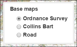
Select one or more of the following check boxes:
- Road—The Bing Road base layer map displays vector imagery of roads, buildings and geography:
- Aerial (Satellite)—The Aerial base layer shows satellite imagery (some of the aerial images may be blurred to protect sensitive sites):
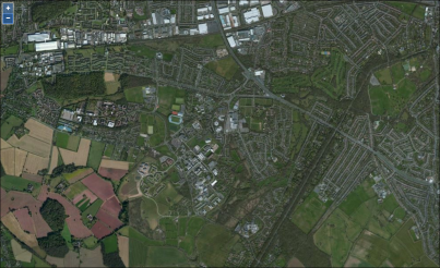
- Aerial with Labels (Hybrid)—The Aerial with Labels (or Hybrid) base layer shows satellite imagery with an overlay that shows roads and major landmarks (some of the aerial images may be blurred to protect sensitive sites). This base layer allows users to quickly identify an area of satellite imagery where they may want to zoom in to see more detail. A typical map looks like this:
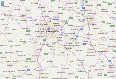
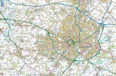
- Collins Bart—Collins Bartholomew is a provider of digital map data, services and solutions. This base layer displays a road map of the UK. For Collins Bart mapping, you must set a Default Zoom level of between 10 and 13 (see Default Zoom above). A typical map looks like this:
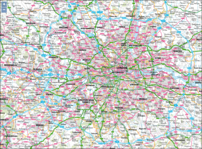
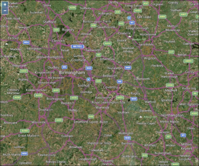
- Ordnance Survey—Ordnance Survey is the national mapping agency for the UK. The Ordnance Survey (OS) base layer provides mapping at scales of 1:50000 and 1:25000 depending on the zoom level that you set. For Ordnance Survey mapping, you must set a Default Zoom level of between 10 and 17 (see Default Zoom above). If you set a Default Zoom level of between 10 and 14, Geo SCADA Expert will display OS base layer mapping at a scale of 1:50000. If you set a Default Zoom level of between 15 and 17, Geo SCADA Expert will display OS base layer mapping at a scale of 1:25000. A typical map looks like this:
- Road—The Bing Road base layer map displays vector imagery of roads, buildings and geography: